diff --git a/00009_Planimetrics_Place_for_water_well/en_article_proofreading.md b/00009_Planimetrics_Place_for_water_well/en_article_proofreading.md
index 7147bd7..16b86de 100644
--- a/00009_Planimetrics_Place_for_water_well/en_article_proofreading.md
+++ b/00009_Planimetrics_Place_for_water_well/en_article_proofreading.md
@@ -2,60 +2,56 @@
keywords:
- planimetry
- set of points that share a property
-is_finished: Nearly
+is_finished: False
---
-# Determining the location for the well
+# Locating a Well on the Property
+<!-- V nadpisech/názvech by měla být slova s velkými písmeny. Formulace názvu mi přišla méně šikovná s chybným členem u studny, tak navrhuji trochu pozměnit. -->
+If we want to have a well on our property, we must carefully consider
+its placement to maintain a sufficient distance from potential sources of possible contamination.
+<!-- Určitě na tomto místě doporučuji nahradit "pollution" slovem "contamination". Slova mají velmi podobný význam, ale v kontextu tohot textu, zcela jistě patří použít "contamination". -->
-If we want to have a well on the property, we must carefully consider
-its location in order to maintain a sufficient distance between the
-well and sources of possible pollution.
+These required distances vary according to the type of potential contamination. Let's say that for less permeable environments, the required distances are given as follows:
-These distances are different according to the type of possible
-pollution. Let's say that for a poorly permeable environment they are
-given as follows:
-
-1. cesspools, small treatment plants, sewage connections: $12 \text{ m}$;
+1. cesspools, small sewage treatment plants, sewage connections: $12 \text{ m}$;
2. liquid fuel tanks for individual heating located in a residential building or a separate auxiliary building: $7 \text{ m}$;
-3. stables, urine pits and manure pits for the small housing of individual livestock: $10 \text{ m}$;
+3. stables, urine pits and manure pits for the small-scale housing of individual livestock: $10 \text{ m}$;
4. public roadways: $12 \text{ m}$;
-5. individual washing areas of motor vehicles and drain pipes and gutters leading from them: $15 \text{ m}$.
+5. individual washing areas for motor vehicles and drain pipes and ditches leading from them: $15 \text{ m}$.
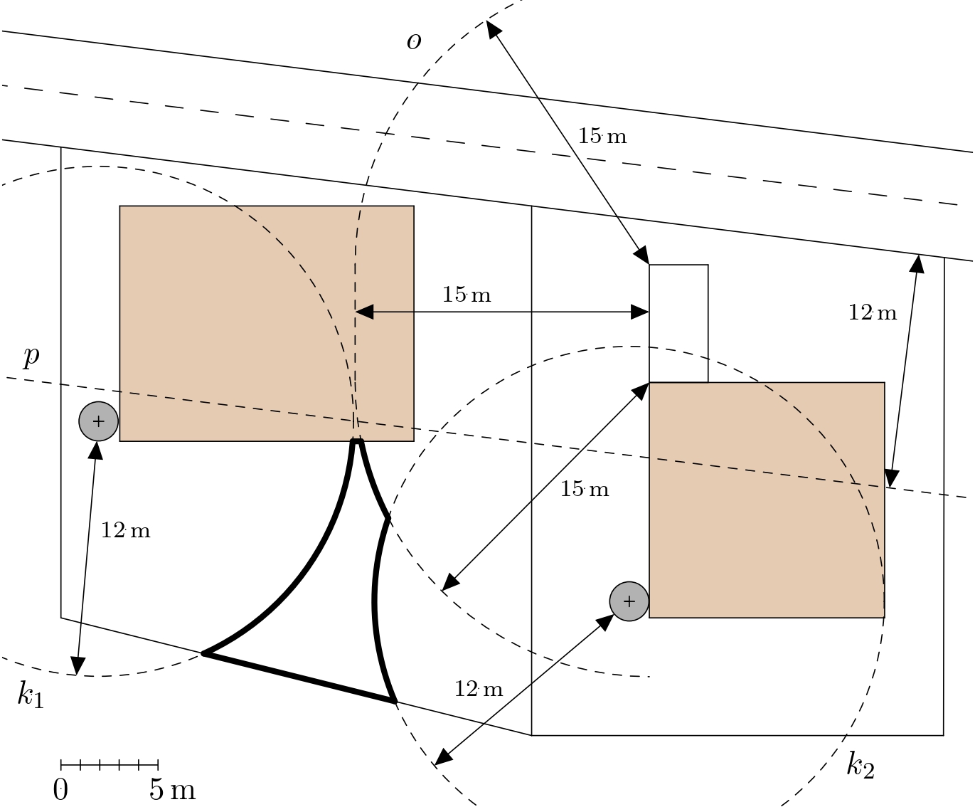
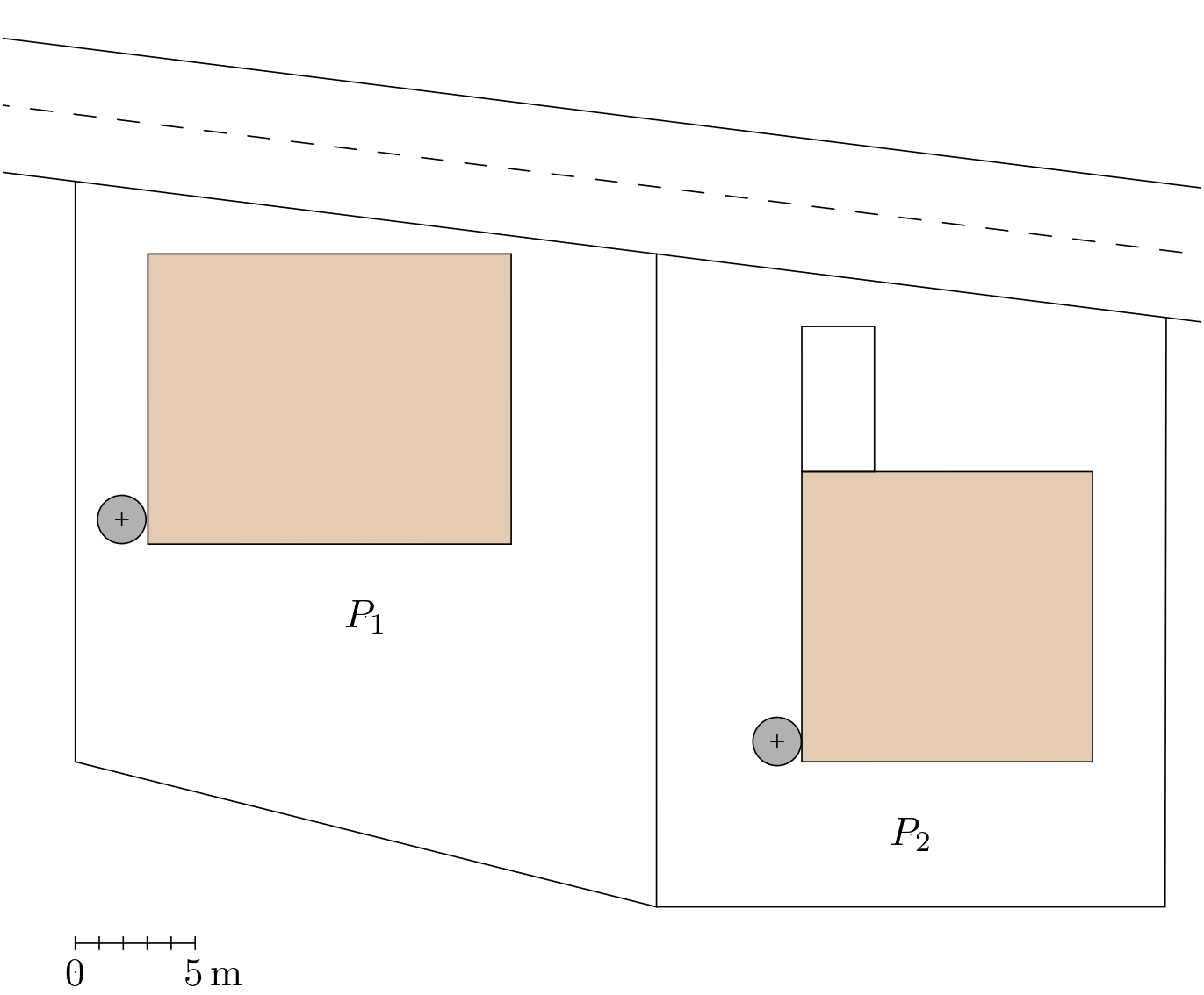
> **Exercise.** A well needs to be built on the plot $P_1$ (shown on the plan in the figure).
> The plan shows where a house (rectangle) and a cesspool (circle) are
> located on the plot $P_1$, and where a house (square), a cesspool
> (circle) and a car wash area (rectangle) are located on the
-> neighboring plot $P_2$ ). The plan also shows the road leading
-> around both plots. Mark the space in the plan in which the well can
-> be placed according to the rules.
+> neighboring plot $P_2$. The plan also shows the road passing by
+both plots. Mark on the plan the area where the well can
+ be placed according to the rules.
>
> 
-*Solution.* We mark on the plan the areas where the well must not be.
+*Solution.* We mark on the plan the areas where the well must not be placed.
-Since the well must be at least 12 m away from the cesspool, this
-prohibited area will be shown on the plan as a concentric circle with
-a marked circle and a radius 12 m larger. The boundaries of the
+Since the well must be at least 12 m away from a cesspool, this
+prohibited area on the plan will be shown as a circle centered on
+a marked circle with radius 12 m larger. The boundaries of the
prohibited areas for both cesspools are represented by circles $k_1$
and $k_2$ in the figure.
-The prohibited area relating to the road on the plan is the strip
-bounded by the edge of the road adjacent to the land and a line
-parallel to it at a distance of 12 m (in the figure, it is the line
+The prohibited area related to the road on the plan is the strip
+bounded by the edge of the road adjacent to the plots $P_1$ and $P_2$ and a line
+parallel to it at the distance of 12 m (in the figure, it is the line
$p$).
Finally, we construct the border of the forbidden area related to the
-car wash area. This is an oval $o$ in the plan, which consists of four
-line segments, parallel to the sides of the rectangle and 15 m away
-from them, and four circles with centers at the vertices of the
-rectangle and a radius of 15 m. The relevant part of this oval is
+car wash area. The border has shape of an oval denoted $o$ in the plan. This oval consists of four line segments, parallel to the sides of the rectangle in distance of 15 m and parts of four circles with centers at the vertices of the rectangle with a radius of 15 m. Only the relevant part of this oval is
marked in the figure.
+Now, it is possible to define the area suitable for digging a well. It
+is the part in the plot $P_1$, which is the outer part in the sense that it does not lie in any of the
+prohibited areas. Its border is marked with a bold line in the figure.
+<!-- Formulace v posledním odstavci není anglicky špatně, ale významově neodpovídá. Tj. výraz "outer part of the plot $P_1$" nedává myslím správný smysl. To by znamenalo, že oblast je úplně mimo pozemek P1, což být nemůže, když studna má být na pozemku.
+Proto jsem formulaci upravila.-->
-Now it is possible to define the area suitable for digging a well. It
-is the outer part of the plot $P_1$, which is not in any of the
-prohibited areas. Its border is marked with a thick line in the
-picture.